Landscapes of the Dead Research Project [LOD]
Aerial and Pedestrian Site Monitoring at Fifa an Early Bronze Age I Cemetery on the Dead Sea Plain, Jordan
Project Directors: Morag M. Kersel and Austin (Chad) Hill
Department of Antiquities Collaborators: Mohammad al-Zaharan, Jehad Darweesh, Basil Halasah, Dr. Jemilah Ishtawey
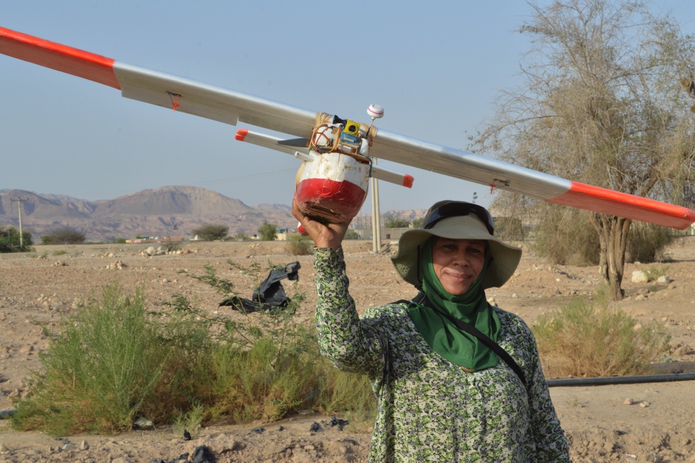
The Landscapes of the Dead Research Project is using Unmanned Aerial Vehicles [UAVs] to study archaeological site looting to understand better both the ancient and modern uses of an Early Bronze Age mortuary site. A fixed wing UAV and a multi-rotor copter (DJI Phantom) provide a platform for stable, low elevation aerial photography, making it possible to document (through images) looting and bulldozer/backhoe destruction at Fifa. The images also allow for the generation of spatial data for digital mapping (see Kersel and Hill 2019; 2020).

The primary objective of the Landscapes of the Dead Research Project is to assess (through aerial photography and a pedestrian survey) the Early Bronze Age (EBA, c.3600-2000 BCE) archaeological landscape at Fifa to understand better both the ancient and modern uses of a mortuary site. The process of formally recording this site began in 2011 with the creation of a site map and the initial groundtruthing. The site is under threat from systematic looting due to the demand for artifacts in the antiquities market and construction practices mining the site for cobbles and gravel.
As part of a larger, comparative analysis of other Early Bronze Age cemeteries (Bab adh-Dhra’, Jericho, and Naqa), this study contributes a much-needed controlled aerial survey of the cemetery of Fifa: providing a baseline for future site monitoring of this threatened landscape. This project demonstrates the efficacy of using UAVs to produce images and data that aid in site assessments and monitoring. The project will also make potential suggestions for cultural heritage protection strategies to safeguard the past.
Landscapes of the Dead Research Goals:
- To obtain quantitative information on the scale and intensity of looting at the EBA cemetery at Fifa using innovative aerial photography in combination with a pedestrian survey.
- To continue recording and mapping the threatened landscape of the EBA site of Fifa.
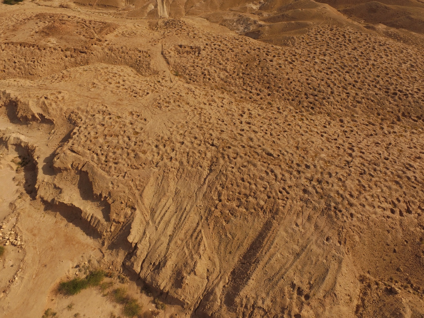
Four seasons of aerial survey at the site of Fifa, an EBA 1A cemetery site identified as one of the so-called “Cities of the Plain”, provide several take-home messages about looting in the region which reinforce similar statistical findings of Contreras and Brodie (2010b) from their analyses using Google Earth©. UAV-generated data allow for the production of accurately georeferenced orthophotographs and Digital Elevations Models (DEMs) that can be compared from one year to the next. High-resolution orthophotographs allowed careful documentation of the 3723 looters’ pits present at the site. New looting was detected by visual inspection (for instance new pits could often be identified by fresh (moist) dirt) and changes in elevation due to the digging of new looting pits and the related creation of new back dirt piles. During the aerial surveys, some looting could be identified in near real-time by comparing new imagery to old imagery, allowing the immediate groundtruthing of patterns and anomalies noticed in the aerial images. Additional patterns were identified via post-processing of the drone data, and analysis in GIS, that could be groundtruthed in following seasons. In both instances, researchers could walk around the landscape with aerial images in hand to check on and confirm identified changes. Over the course of four field seasons, 61 new holes were documented at the site. Additionally, significant and unexpected damage to the site, in the form of gravel quarrying, was identified by a combination of the high resolution, accurate change-over-time DEM data followed by direct inspection on the ground. This type of damage was not the focus of the survey and would have been easily missed by only looking at aerial photographs, but is a definite source of site destruction. After identifying areas being damaged by this quarrying, it was possible to detect burials that had been destroyed by this activity. As this shows, the data created from drone surveys provide persuasive proof of historic and ongoing looting and site damage at the Early Bronze Age site of Fifa.
Historical Background of Fifa
The Early Bronze Age IA (EBA, c.3500-3200 BCE) cemetery of Fifa contains thousands of cist tombs – to date the Landscapes of the Dead survey has identified over 3700 looting holes, a number which does not reflect any unexcavated/yet to be identified tombs. In the archaeology of the southern Levant, this site represents an incredibly important resource for researchers: it is one of only four large known EBA cemeteries (the others being Bab-adh Dhra’, Jericho, and Naqa). In 1934 Frank was the first to mention the Early Bronze site at Fifa, later confirmed by Glueck (1937) in his aerial flyovers at the site.
The first mention of negative interactions (looting, unauthorized construction activity, development) is in 1973 by Walter Rast and R. Thomas Schaub (1974) in a report on their Survey of the Southeastern Plain of the Dead Sea. They note the looting of tombs and the theft of material culture from this cemetery. In the Southern Ghors and Northeast ‘Arabah Archaeological Survey (MacDonald et al. 1992) Fifa is identified as Site 76 and the Iron Age (Iron II) structure as Site 75 (at the western end of the site). Surveys conducted in the mid-1980s by MacDonald and colleagues confirm looting in the area. In 1989-1990 Rast and Schaub identified eighteen tombs, excavating eleven during a short (3-week) season at Fifa. In 2001, Dr. Mohammed Najjar excavated an area of 20m x 10m (approx. 177.5 sq. m) uncovering 50 graves, as part of a Department of Antiquities salvage expedition in response to reports of increased looting at the site.

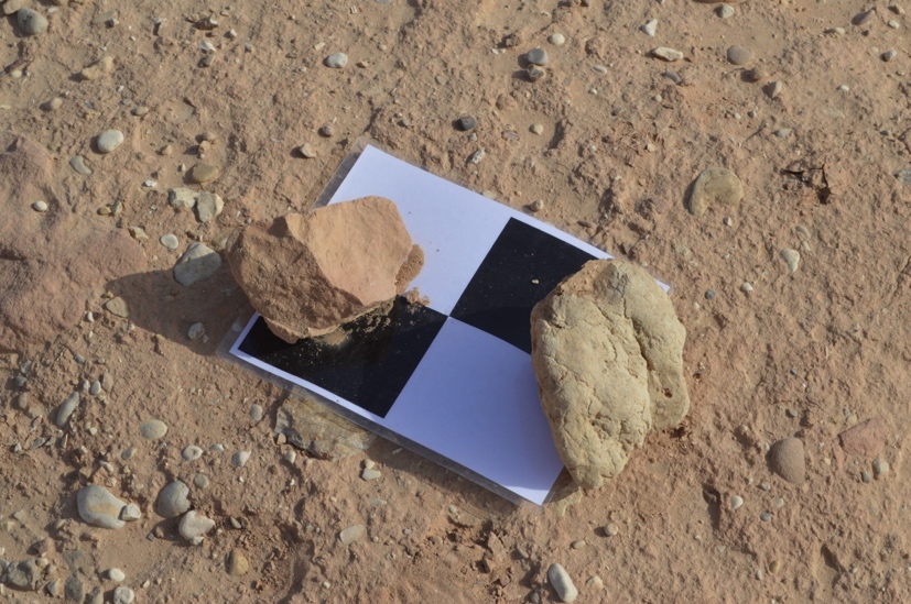
In the 2011 season, Follow the Pots Research Project [FTP] surveyed and mapped the extent of the cemetery using a handheld GPS unit and a Total Station. Data from previous excavations and visits to the site, in combination with aerial photographs, indicate that approximately ca. 3700 looters’ pits exist at the site, many of which destroyed stone-lined cist tombs containing secondary burials, ceramic and stone vessels, shell bracelets, stone mace heads, and beads.
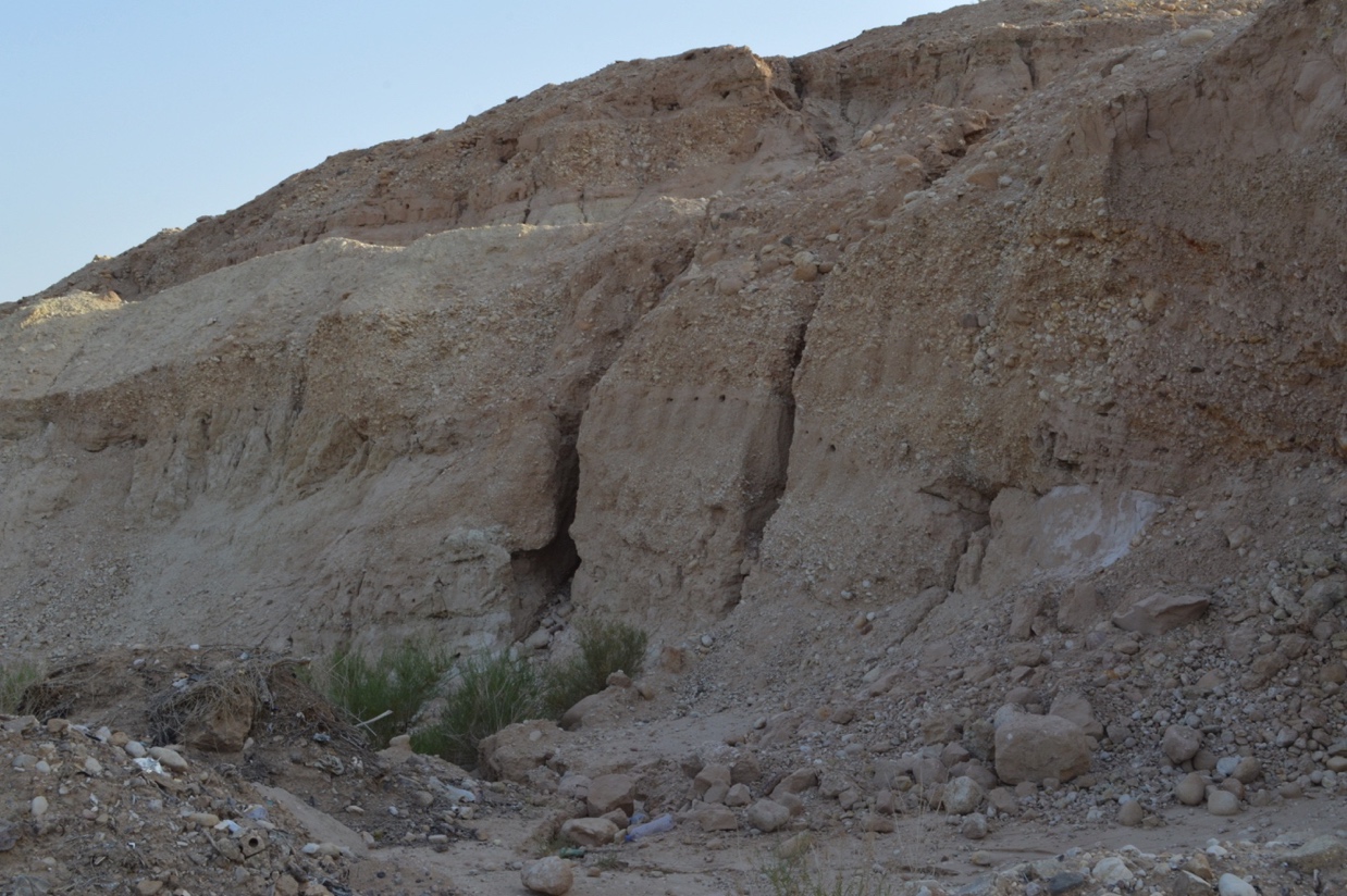
In 2011 the site resembled a moonscape (as it does now), with looters’ trenches extending across rolling hills as far as the eyes can see, and the ground is covered with the spoil heaps of dirt, human skeletal remains, and broken artifacts. Such a scale of destruction makes total documentation of all looters’ pits impossible, but we addressed the salient question asked by Webb and Frankel (2009), which challenges conventional archaeological investigations by asking the salient question: Is a cemetery that has been robbed and pillaged for generations worthy of systematic research? Groundtruthing of the looted Early Bronze Age IA cemetery at Fifa in 2011 demonstrated that looted cemeteries are crucial to a holistic methodical investigation of an archaeological landscape.
Aerial Photography. The primary element of this field project is the use of aerial photography as a method of site assessment and monitoring. The advantages of gaining a good aerial view of the ground are well established and appreciated by archaeologists; a high viewpoint permits a better appreciation of fine details and their spatial relationships within the wider site context. Rather than relying on satellite images or Google Earth©, which provide insufficient resolution for identifying site details, early in the project multiple images of the site were taken using a remote controlled plane (a resolution of 4cm/pixel vs 40cms/pixel for satellite images). The LOD project undertook an aerial drone survey at Fifa from 2013 to 2016. Over the course of four seasons, as technology improved, a variety of fixed-wing and rotary-wing drones were used. The aerial surveys were designed to record the site at centimeter-level resolution to generate undistorted orthophotographs (see Figure 2) and digital elevation models (DEMs) of the site. After photogrammetric processing using Agisoft Photoscan Pro, the resulting data were analyzed via visual inspection and DEM comparison to identify new destruction at the site each year (see Kersel and Hill 2019).
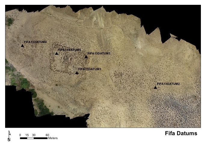
In 2013, our first season, we set a series of datums around the site as bases for the total station. Each year we then place a series of mapping targets (typically 50m apart on north-south transects, also 50m apart). The black and white targets are visible in the images taken from the drones and are used to overlay maps in the same exact location from year to year allowing for the assessment of landscape change.
Using a remote controlled plane and a DJI Phantom quadcopter it is possible to both document looting and site destruction at Fifa as well as generating spatial data for digital mapping. Aerial survey at the site utilized image post-processing to produce high-resolution digital maps of the site.
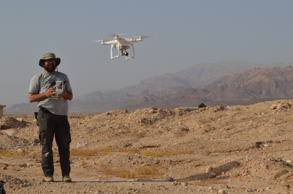
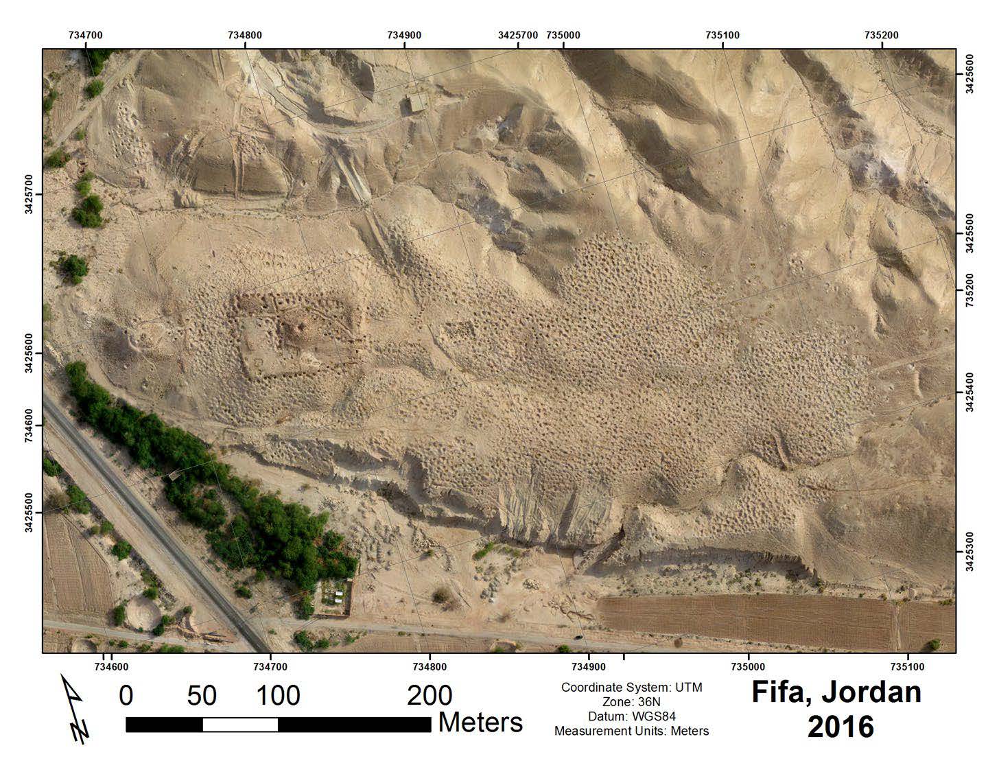
Image post-processing creates accurate spatial models of the site in the form of orthophotographs and Digital Elevation Models (DEMs). These models, when incorporated into the site-wide GIS built by the pedestrian survey, have created a baseline from which to observe change over time of the archaeological landscape. Once fully processed, the DEMs and orthophotographs are be compared to undertake a chronological assessment of looting at Fifa that will allow for determinations of whether any of the looter’s holes had been revisited; if the looting was recent; and if there is a discernible difference in looting episodes.

Results
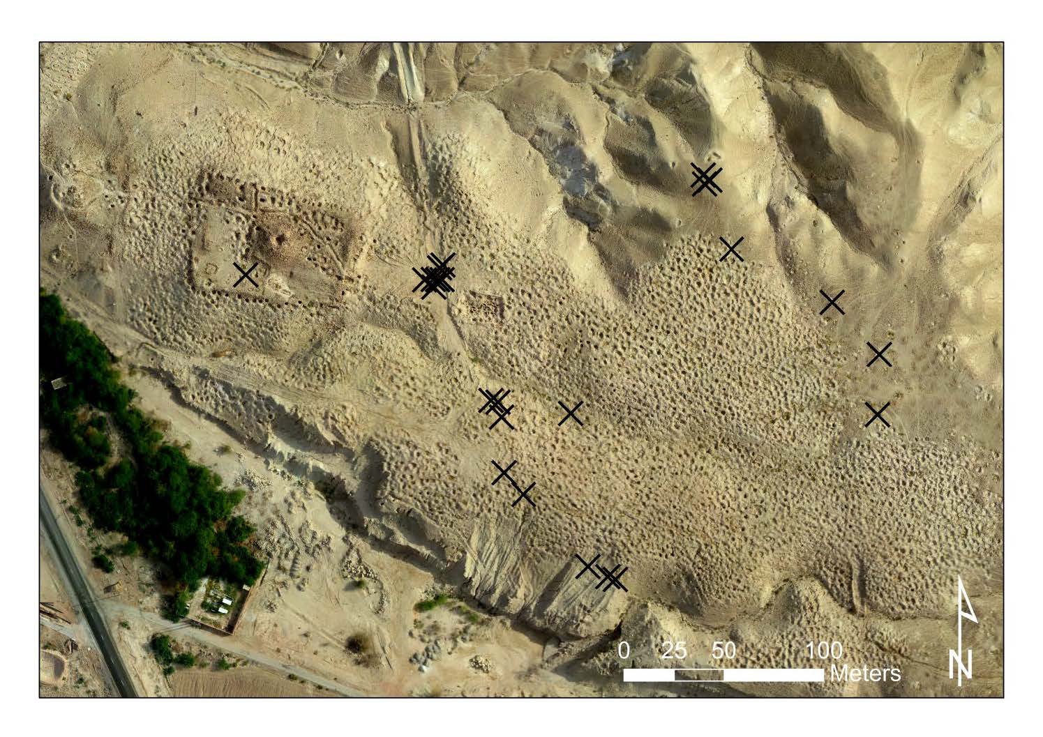
There are several important results of four seasons of site monitoring with drones at Fifa. First, looting is still occurring, perhaps at a reduced rate. At least 34 new pits were dug between the 2013 and 2014 field seasons. While this is only a small proportion (less than 1%) of the total holes at the site, it still represents a significant number of looted artifacts and potential prices realized. If each grave might have contained an estimated 6-30 ceramic vessels (Rast and Schaub 1990), then the total number of saleable vessels from these 34 graves could be as many as 1020. In today’s market, these pots sell for between $30 and $150 resulting in a lower estimate of $6120 and a high estimate of $153,000.
Season 2013-2014
- Looting is ongoing – 34 new looting episodes each with a grave
- Estimated number of saleable pots = between 204 and 1020 from 34 graves
- Today’s market $30-$150 USD /pot = $6120 (low estimate) and $153,000 USD (high estimate)
Ethnographic interviews (a separate element of the Follow the Pots Project) with local looters suggest that they receive between 5 and 7 JD ($5-10 USD) per pot, which means they could be making between 3% and 15% of the final price realized paid by the consumer (contra to the findings of Brodie (1998) Brodie and Contreras 2012).
The 34 new holes are concentrated, not surprisingly, in the area of the main wadi that runs through the site, and down along the lower slopes in the southwestern edge – areas less visible from the road.

Season 2014-2015
Assessment of maps between 2014 and 2015 indicate almost no new looting (approximately 3 new holes). Three new holes analyzed under the same set of criteria above would generate the following statistics:
- Looting is ongoing – 3 new looting episodes each with a grave
- Estimated number of saleable pots = between 18 and 90 from 3 graves
- Today’s market prices of $30-$150 USD /pot = $540 (low estimate) and $13,500 USD (high estimate)
What factors led to less looting at the site? 1. Public outreach programs carried out by organizations like the Petra National Trust on “Why Looting Stops us From Learning?” (see Kersel and Hill 2019) 2. Department of Antiquities oversight and management programs carried out by the staff from the Safi Inspectorate and the Museum at the Lowest Place on Earth. 3. There is no market for Early Bronze Age pots and as a result, no one is buying the material at any level in the commodity chain of production (looting and theft) – distribution (middlemen and dealers) – consumption (institutional and individual buyers) – see Kersel 2007; Kersel 2019 for a full discussion of illegal antiquities commodity chains. Is there really less looting at the site or is this just anomaly in this research?
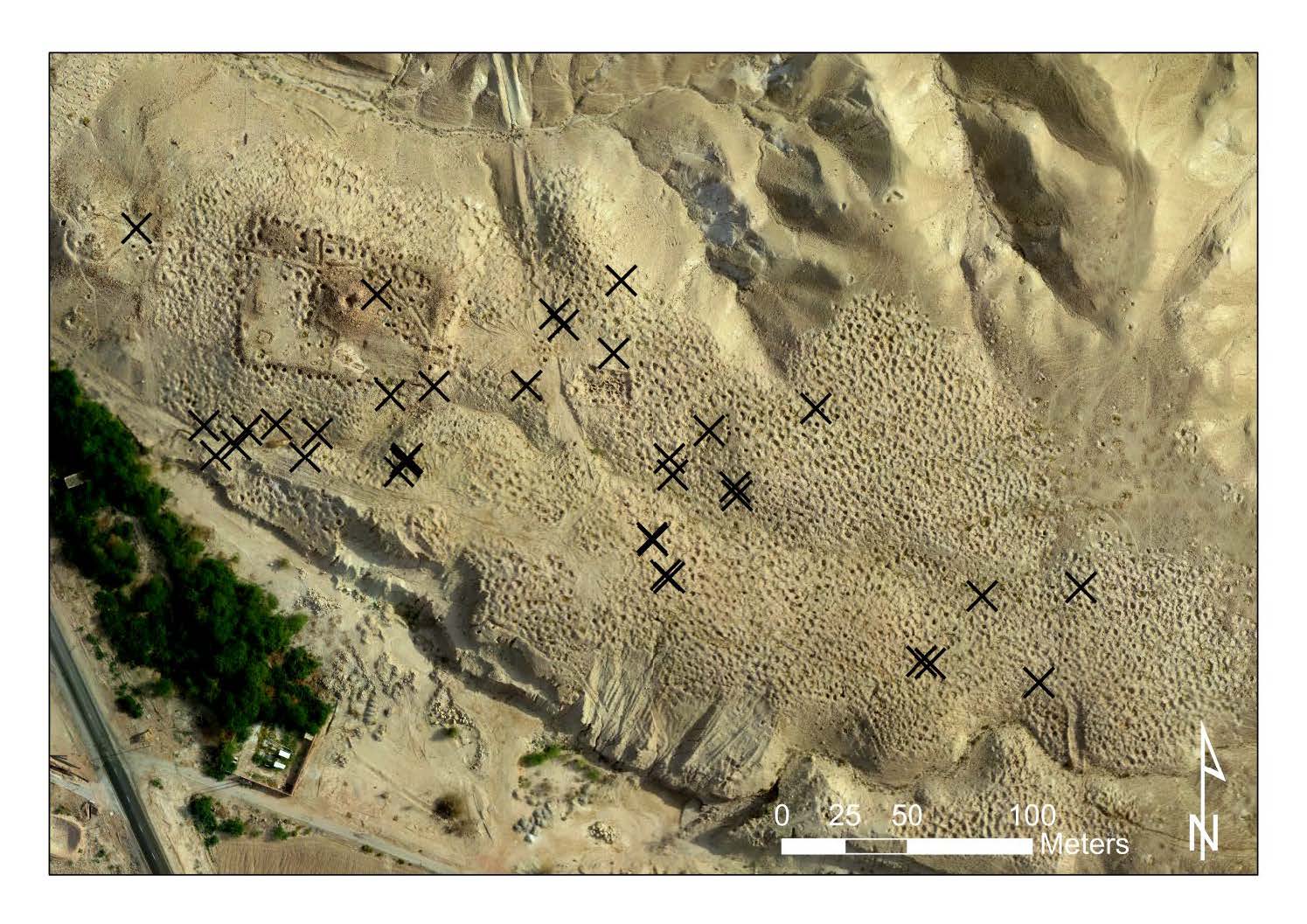
Seasons 2015-2016
In the analysis of images between the 2015 and 2016 seasons, we identified 24 new holes. The black Xs indicate the location of new holes. The patterns of looting are interesting in their locations. Along the northern edge, there are 4 new holes beyond the edge of the site, which were undoubtedly not successful excavations of cist graves. In the backdirt pile of the cluster of holes west of the 2001 scientific excavations of Mohammad Najjar, we recovered a complete vessel (see the section below on What Looters Leave Behind).
- Looting is ongoing – 24 new looting episodes
- Estimated number of saleable pots = between 144 and 720
- Today’s market prices of $30-$150 USD /pot = $4320 (low estimate) and $108000USD (high estimate)
Table 1: Potential income generated from the looted holes at Fifa (see Kersel and Hill 2019)
Year | # New looted graves | # Range of Salable pots | Low estimate USD | High estimate USD |
2013-2014 | 34 | 204-1020 | $6120 | $153000 |
2014-2015 | 3 | 18-90 | $540 | $22500 |
2015-2016 | 24 | 144-720 | $4320 | $108000 |
TOTAL | 61 | 366-1830 | $10980 | $274500 |
These preliminary analyses indicate that the looting at Fifa is ongoing and since 2013, there is a potential to realize a financial gain in the range between $10980-274500 USD. This chart does not reflect the prices paid to the looter (typically between $5-10 USD per pot) or how many hands the artifacts pass through in the associated financial transactions to the eventual purchasers.
What looters leave behind?
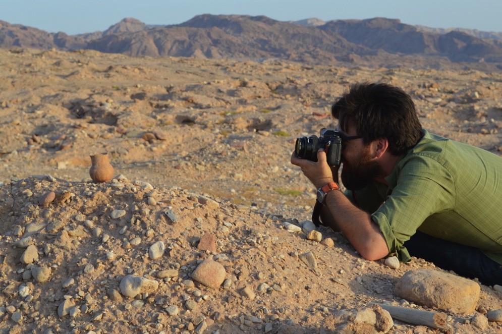
Between the 2015 and 2016 field seasons, there was clearly a lot of rain/water at the site. As a result, it was difficult to discern, through pedestrian survey, new looting patterns and fresh dirt piles. Almost everything looked like an old spoil pile, which is possibly not the case. The rain did uncover some items previously undetected in the landscape. This Early Bronze Age vessel was recorded in situ and deposited at the Museum at the Lowest Place on Earth for accession by Director Mohammad al-Zaharan.
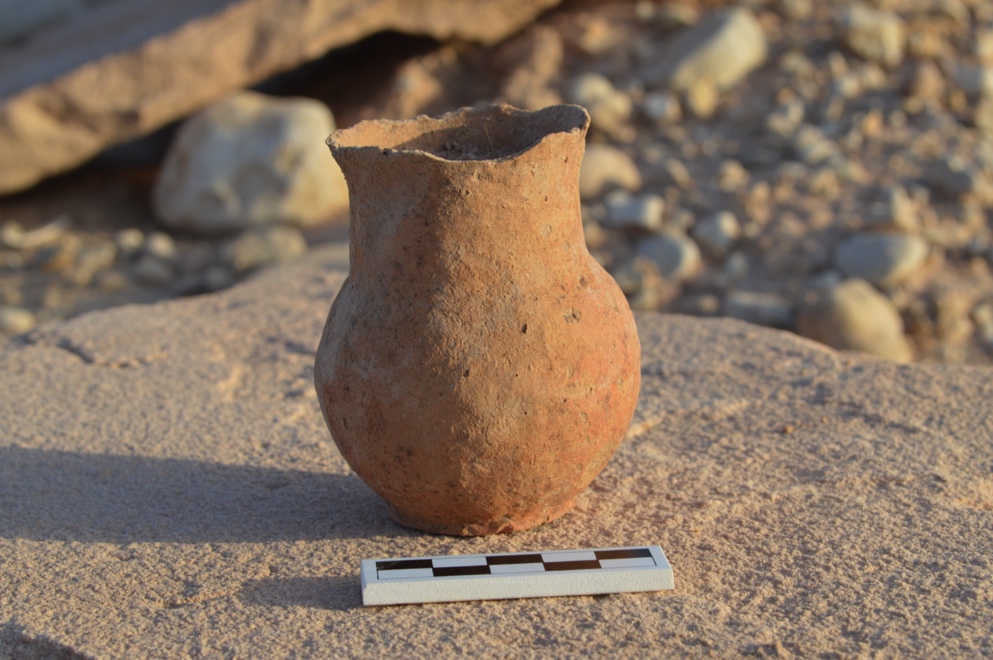
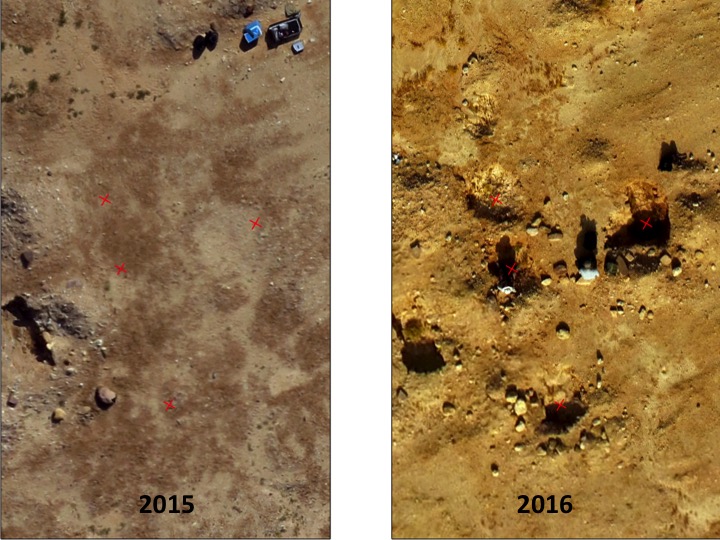
The same area in 2015 and then 2016 (with 4 new looter holes). The complete vessel recovered from the backdirt pile was one from the looter’s holes newly identified in the analysis of images from 2015 and 2016.
Construction Practices
There has been a notable increase in the use of mechanical diggers and backhoes at the site since the initial season in 2011. Clearly, individuals are mining the site for the valuable cobbles and gravels for building works.
Conclusions and Recommendations
The myriad consequences of the illegal excavation and construction practices at Fifa on the interpretation of changing mortuary practices and social differentiation may never be known and valuable data has been lost, distorting our understanding of Early Bronze Age burial customs. Damage caused by looting and development/construction places severe limitations on attempts to accurately describe the orientation and original condition of the tomb chambers and the extent of the cemetery site, creating lacunae in the archaeological record. This project will make a significant contribution to assessing the efficacy of aerial (UAV/drone) photography as a means of monitoring archaeological site destruction.
Acknowledgments
We gratefully acknowledge Dr. Monther Jamhawi, Director General of the Jordanian Department of Antiquities for permission to work on this project. This work would not have been possible without the assistance of Aktham Oweidi Abbadi and Hussein Saleh Dhabour of the Survey and Excavation Office at the Department of Antiquities. It was a privilege and a pleasure to work on the mapping and recording of the Fifa cemetery. Our departmental representative Dr. Jemilah Ishtawey provided valuable insights, field assistance, and logistical support, which facilitated our fieldwork. Head of the Safi Inspectorate and Director of the Museum, Mohammad Zaharan was extremely helpful in ensuring a successful field season, we are grateful for his assistance. We were hosted in the museum and we very much appreciate the opportunity to stay in those facilities. We also received logistical support from ACOR for which we give many thanks. This fieldwork was generously funded by a grant from DePaul University.
References
Brodie, N.J. (1998) Pity the Poor Middleman. Culture without Context no 3, 7-9.
Brodie N. J. and D. Contreras (2012) The Economics of the Looted Archaeological Site of Bab edh Dhra’. In P.K. Lazrus and A.W. Barker (eds.) All The Kings Horses: Looting, Antiquities Trafficking and the Integrity of the Archaeological Record, pp. 9-24. Washington DC: Society for American Archaeology.
Contreras, D. and N. J. Brodie (2010) Quantifying Destruction: An Evaluation of the Utility of Publicly Available Satellite Imagery for Investigating Looting of Archaeological Sites in Jordan. Journal of Field Archaeology 35(1): 101-114.
Frank, F. (1934) Aus der ‘Araba I: Reiseberichte. Zeitschrift des Deutschen Palastina-Vereins 57: 191-280.
Glueck, N. (1937) An Aerial Reconnaissance in Southern Transjordan. Bulletin of the American Schools of Oriental Research 67:19-26.
Kersel, M.M. (2007) Transcending Borders: Objects on the Move. Archaeologies. Journal of the World Archaeological Congress 3 (2): 81-98.
Kersel, M.M. (2019). Itinerant Objects. The Legal Lives of Levantine Artifacts. In A. Yasur-Landau, E.H Cline, and Y.M. Rowan (eds.) The Social Archaeology of the Levant, 594-612. Cambridge, UK: Cambridge University Press.
Kersel, M.M. and A.C. Hill. (2019) The (W)Hole Picture: Responses to a Looted Landscape. International Journal of Cultural Property 26(3): 305-329.
Kersel, M.M. and A.C. Hill. (2020) Databases, Drones, Diggers, and Diplomacy: The Jordanian Request for a US Cultural Property Bilateral Agreement. Journal of Field Archaeology 45 (sup1): S101-S110.
MacDonald et al. (1992) The Southern Ghors and Northeast ‘Arabah Archaeological Survey. Sheffield Archaeological Monographs 5. Sheffield: University of Sheffield.
Najjar, Mohammad (2001) As-Safi and Fifa – Al-Karak District. Munjazat Department of Antiquities, p. 38.
Rast, W. and R.T. Schaub (1974) Survey of the Southeastern Plain of the Dead Sea, 1973. ADAJ 19: 5-55.
Rast, W. and R.T. Schaub (1990) Final Report for the National Endowment for the Humanities. Unpublished report.
Webb, J. and D. Frankel (2009) Exploiting a Damaged and Diminishing Resource: Survey, Sampling and Society at a Bronze Age Cemetery Complex in Cyprus. Antiquity 83: 54-68.